Categotry Archives: Plumstead

by

A Trove of Documents Saved from Destruction

No comments yet

Categories: Abolitionists, Buckingham, Graves, Langhorne, Maps, Middletown, Plumstead, Quakerism, Solebury

Petition to Congress

A few months ago my grandfather decided to a do a little spring cleaning. There was a storage unit in our barn that hadn’t been touched in years, full of mildewy furniture and worthless miscellany. He came across a metal container full of maps, mostly showing local topography and zoning. My aunt suggested that I might want them, so they escaped the trash heap.

When I got down to the barn I found a pile of mostly junk, covered in a plastic tarp because we were expecting rain. I found a few items worth keeping: the sled my great-grandmother had when she was a little girl growing up in Battle Creek, Michigan, a wooden tricycle that belonged to my grandfather, and a few plastic trucks for my son to play with. I found the box of maps and popped open the latch, and immediately knew that the contents were far more important than my grandfather had realized.

There were dozens of maps, but among the rolls of paper I recognized a draft of the map my great-grandfather made for the Solebury Friends Meeting burial ground in the 1960s. Then I noticed another roll that was clearly a much older material. With the box sitting in the gravel driveway, I rolled the map out a few inches and discovered that it was in fact two maps rolled together.

SoleburyFriendsMeeting-Burial Map-1907(small)

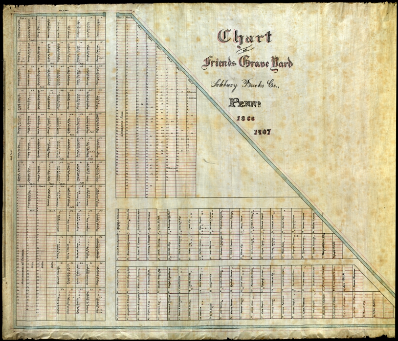
The first was from 1907.

The second was from 1866.

They were the original maps that by great-grandfather used as a reference for the modern map, and they’d been sitting in our barn for decades, totally forgotten.

I called the person currently in charge of the graveyard to tell him about my find and offered to bring it to the Friends Historical Library at Swarthmore College to deposit it with the rest of the Meeting’s original records, and I held on to them for a few months until I had time to make the trip.

A couple weeks ago I finally I finally had a day off, and decided to bring the maps to Swarthmore. My timing was fortuitous. That Monday I led a graveyard tour at Plumstead Friends Meeting. We assembled in the meetinghouse, and as I led the group outside towards the burial ground, a woman approached me with a box of documents about the meeting. At the time I was too focused on the tour to discuss it, and suggested that she talk to the clerk of the meeting. The next day, however, I was consumed by curiosity. I already had plans to go down the the Friends Historical Library that week, and thought I might be able to bring those papers as well. Luckily I ran into her in Doylestown a couple days later and proposed that I take them for her. She agreed.

When she dropped the documents off the next day, she brought a lot more than the Plumstead material. She also brought a collection of documents from Buckingham Meeting, and there was so much that it took her two trips to unload it from her car.

The Plumstead material turned out to be the notes and research prepared for a pamphlet published for the meeting’s 225th anniversary celebration on 1953, as well as notes about the ceremony itself. There were also two large photographs that were used in the pamphlet, one from c.1875, and one from 1953.

The Buckingham material was rather varied. One box contained about a dozen copies of the book published for Buckingham Meeting’s 225th anniversary in 1923, as well as a block print of the meetinghouse that was used for that book. There was a folder with newspaper clippings and other 20th Century material. Finally, there was a cardboard box that had been saved from Buckingham Meeting by the woman’s father. At some point a few decades ago, the members of Buckingham meeting had decided to indiscriminately “clean” their attic, and this box was a subject of the purge. Like the burial map from Solebury, these documents were almost destroyed.

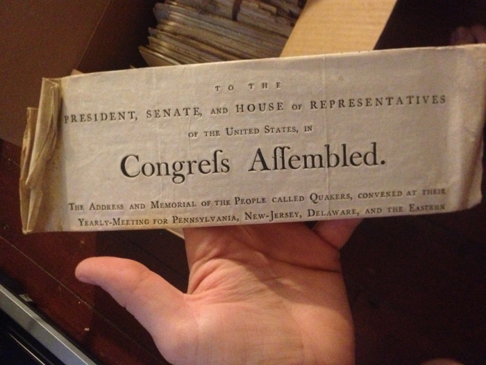
When I opened this final box I got goosebumps. I could tell by looking at the parchment that they were old. Really old. Most of them were tied together with string into little bundles, with a few groupings of loose papers between them. I saw the date “1776” peeking out from one of the bundles. When I brought them home and examined them further I found that some documents dated back to the beginning of the 1700s, and in addition to material from Buckingham, a lot of the documents actually came from Middletown Monthly Meeting. Most of them were excerpts from annual conference of Philadelphia Yearly Meeting, and epistles from the yearly meetings in London and Philadelphia. Some were testimony against members of meeting, or letters from people willingly leaving the Society of Friends. There were a few more recent documents that dealt with the Civil War. Perhaps the most interesting document is a letter written from a Quaker aid mission during the British occupation of Boston. She had kept them in storage for years, hoping to eventually deposit them in the archive, and I was finally able to bring them for her.

Swarthmore Donation - Stack of Papers

For the sake of brevity, I will show the individual documents in separate posts:

by

Corpse Thieves in Plumstead

No comments yet

Categories: Crime, Death, Graves, Plumstead

If you visit Plumstead Friends Meeting, you’ll find it pleasantly sedate. The meetinghouse seems unconcerned with the passing of time (it’s only heat source is a wood stove in the center of the room), and there’s a simple graveyard enclosed by a plain stone wall, containing graves as old as the nation itself. But the graveyard has not always enjoyed this state of placidity. In the summer of 1856, some of the cemetery’s occupants were torn from their slumber in a daring grave robbery. The following advertisement appeared in the Intelligencer in the August of 1856:

Notice to Trespassers.

All those persons who, regardless of law and good order, recently trespassed on the premises of the Society of Friends of Plumstead, by abruptly driving into the Grave Yard with wagon and horses, disfiguring some of the graves, and opening others, and disinterring several coprses, and taking them away without consent of the Sexton or any of the Trustees, are hereby requested to come forward and render satisfaction for the same without delay, which may save cost, prevent exposure, and oblige the undersigned.

                                                                              ABRAHAM MICHINER, Committee

                                                                             THOMAS STRADLING, } of Trust.

                                                                             DAVID CARR, Sexton.

           Plumstead, 8th month 26th 1856 -3t.

           N. B.—Notice is also hereby given to all other persons not to commit the like depredations.

(The Spruance Library has a filing cabinet full of news clippings sorted by municipality and topic, which is where I found this little gem.)

An old grave, but maybe not that old. This etching may be the work of a vandal.

The inquisitive guest will find that this cemetery has another secret. If you climb over the far wall and search through the brush, you’ll find the last resting place of the burying ground’s most ignominious residents, Abraham and Levi Doan. They were part of the Doan Brothers gang (brothers Moses, Aaron, Mahlon, Levi, Joseph, and cousin Abraham) who gained notoriety first as Loyalist spies during the Revolution, and then as outlaws after the war. All of them were eventually captured, but Aaron, Mahlon, and Joseph escaped and fled to safety. Their leader, Moses Doan, was the victim of an extrajudicial murder at the hands of a vengeful posse, and is buried in a hedgerow somewhere in Plumstead. The other two, Levi and Abraham, were captured and hanged on September 24th, 1788, and buried at Plumstead Meeting, where they once were members. They lie outside the graveyard wall, forever branded outlaws:

by

The Smallest Kind of Farmer

No comments yet

Categories: Plumstead

The Plumstead census in 1870 includes the following listing for Patrick Conaulty, a 50-year-old widower:

He was an Irish immigrant living on his own with no wife and no family. The enumerator manifests his pity for Mr. Conaulty in the “occupation” column, recording that he is not just a farmer, but the smallest kind of farmer–alone.

As luck would have it, Patrick was eventually joined by his son Hugh, who appears with Patrick on the census in 1880:

Hugh, however, was not so lucky. By 1910 he was working as a farmhand on someone else’s land. In 1920 he appears again, a 71-year-old man, renting his house, working as a laborer, still single and living alone:

The census shows that he immigrated with his father in 1863 and was naturalized in 1880. I wonder if the lonely life they found in Bucks County was an improvement over the one they left in Ireland.

by

Slobbery Run

No comments yet

Categories: Black History, Inns & Taverns, Lower Black Eddy, Places, Plumstead, Racism

The other day I paid a visit to Slobbery Run, a small stream that cuts down from the hillside on River Road and flows into the canal. It wasn’t very slobbery when I came to visit, but I imagine after a hard rain the water flows a bit more impressively through this rocky valley.

From MacReynolds’ Place Names in Bucks County:

Slobbery Run – Small short steam in southeastern Plumstead Township, tumbling through a rocky ravine about a quarter mile east of Lower Black Eddy and emptying into Delaware Division Canal. The water foams over the rough boulders, hence its name. It is a venturesome climb from Delaware River Road up this steep valley, to be paid upon reaching the top with magnificent waves of river scenery.

It’s located just north of Devil’s Half Acre, an unlicensed distillery that operated along the canal in its early days and acquired a raucous reputation. One of the reasons I visited Slobbery Run was to try to pinpoint the plot of land on the boulder-covered hill that a black farmer cleared and cultivated, which I read about in this article by Cyrus Livezy, published in the Doylestown Democrat on November 28th, 1876, and reprinted by MacReynolds in Place Names:

 On the hillside after leaving the old Devils Half Acre house is a modest dwelling erected many years ago by ‘Old Black John,’ who by a vast amount of labor and with more patience and perseverance than is often found in the African race succeeded in rendering a small stony patch susceptible to cultivation, and just beyond this we come to the famous high rocks towering grandly at least eight feet above them. The sun is not visible here and the wintry atmosphere that prevades [sic] this place gives us a taste of that season, and we remember finding a block of winter ice here late April, 1830. Advancing a few rods we pass Rattling Run Cascade and are opposite Moss Giel Rock, which rises from the side of the hill some distance above the road. The ascent is very steep and the distance from the road to the summit of the rock is about three hundred feet. Our fraternal guide offers to lead us up by a circuitous route without difficulty, but climbing steep hills was a favorite amusement fifty years ago, and we resolve to have a taste of it now and in a few minutes, panting for breath, the summit of the rock is reached. Here after resting awhile we contemplate the scenery below, around and far away. On the eastern side is the cascade, so called from a small steam of water flowing through a wildwood glen and over a ledge of rocks. The run formerly bore a name that was rather uncongenial to modern refinement and was changed a few years ago to suit the taste of some Philadelphia ladies; and, although we are generally disposed to accept names as we find them, beg leave to demur on this case (as the steam flows through a thickly wooded glen) to call it Sylvan Run and Sylvan Run Cascade. Moss Giel Rock was dedicated by an ederly [sic] gentleman and some schoolboy companions in 1865, the ceremony consisting of reading Bayard Taylor’s account of the great Burns Festival at Moss Giel in Scotland in 1845. The Broad surface of the rock is smooth and pretty well covered with inscriptions by numerous visitors. Although many years of our life were passed within two miles of this place, we never stood upon the rock before and knew not of its sublimity. To the eastward the head of the Delaware and Raritan Canal feeder, Readings Hollow, Bulls Island and Raven Rock are visible.

It’s amazing to me that, following the rules of politeness in that era, Livezey dances around the word “slobbery” but doesn’t think twice before dropping offensive racial stereotypes.

I didn’t have much luck, and I have no idea if any evidence remains of this old homestead. I looked at an 1876 map of Plumstead, and it seems like the land at the top of the ridge was one large plot, while there were a couple thin strips of separately owned land running between the hill and the canal, one including Devil’s Half Acre and the other with one building shown across the road. It’s possible that John lived there, and that before River Road was widened he had enough cultivatable land to subsist on. I also haven’t been able to identify any African Amercian named John on the Plumstead census records from this era.

UPDATE: I met the owner of what is probably John’s homestead. The old house is gone, but until the 1930’s, it was an old wooden shack raised up on stilts. When the homeowner tore down the house that replaced it (a confused jumble of additions and alterations cobbled together as a residence) to build a new home, the bases of the old wooden stilts were still visible. There’s a small flat area adjacent to the house big enough for a garden.  The other houses immediately past Devil’s Half Acre weren’t built until after World War II, and are therefore unlikely candidates for John’s home site.

The owner of John’s plot also told me that, rather than Slobbery Run, the old-timers used the name Sloppy Gulch.