Categotry Archives: Maps

by

The Forgotten “Negro Burying Ground” at Middletown Friends Meeting

Categories: Black History, Graves, Langhorne, Maps, Middletown, Quakerism, Racism, Slavery

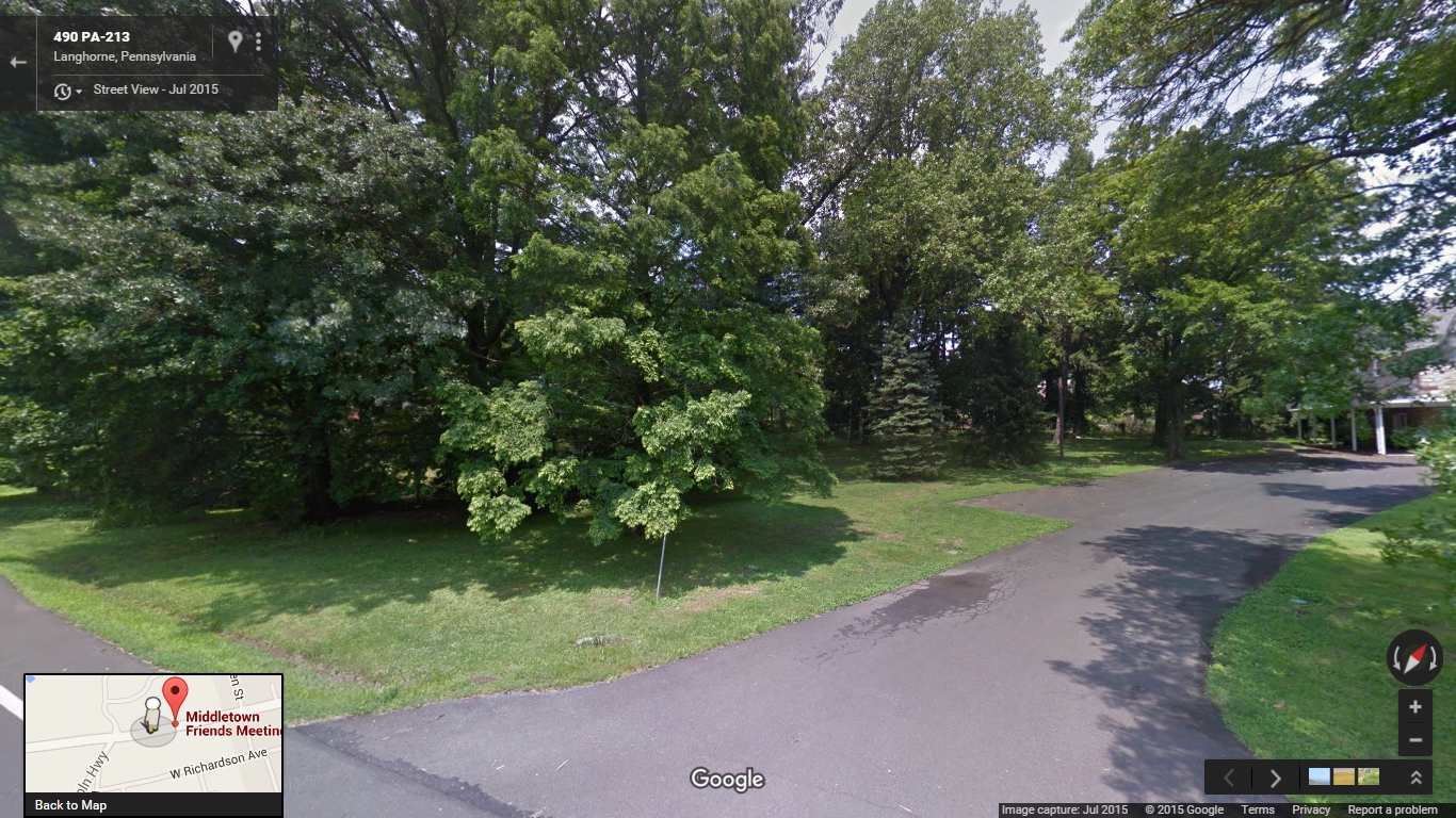
Negro Burying Ground - Street View

Just southwest of the Middletown Friends meetinghouse lies a small burial ground purchased for the interment of African Americans 225 years ago, at a time when almost a third of the county’s black population remained enslaved. There are no headstones or any other visual indicators to distinguish this plot from the rest of the meeting’s shaded lawn, and like other Quaker meetings in the area, Middletown did not begin keeping burial records until after the Civil War. It is therefore unsurprising that this burial ground has been forgotten in the intervening centuries. The current overseer of the cemetery was unaware of its existence, and while a “Negro burying ground” is referred to in the meeting’s property records, I was not able to identify it’s specific location until I discovered the original deed for the land in the archive of the Friends Historical Library.

Throughout the colonial era, burial grounds were places of great social importance to enslaved Africans. For example, in Philadelphia the section of the Strangers’ Burial Ground (now Washington Square Park) that was set aside for blacks drew large crowds on Sundays, holidays, and fair days. During these gatherings the burial ground became an autonomous African cultural space where participants came together to perform African dances and to speak and sing in their native languages. This was not the case in rural Bucks County, where the small scale of slaveholding meant that the enslaved had few opportunities to interact with other Africans. Slaves were permitted to attend the fairs that were held twice each year Bristol, but only on the last day.

Records indicate that early Quaker settlers initially permitted the burial of Africans in their burial ground, but this was quickly curtailed. Middletown Monthly Meeting, located on the western border of Langhorne Borough, set aside a portion of their burial ground for blacks in the early 18th century, but the meeting vacillated with regard to their treatment of the African dead. Middletown Meeting segregated their burial ground in 1703, noting in their minutes, “There having been formerly some Negros Buryed in friends Burying Yard which they are not well satisfied with therefore Robert Heaton & Thomas Stackhouse are ordered to fence off that corner with as much more as they may see convenient, that friends burying place may be of itself from all others.” After the construction of a wall around the burial ground in 1734 the Friends reaffirmed their opposition to sharing their burial ground with African Americans, ultimately declaring in 1739, “this meeting having had the Matter under Consideration it is unanimously agreed that hereafter no Deceased Negros be Buried Within the walls of the graveyard Belonging to this meeting, & Adam Parker, Jonathan Woolston & Joseph Richardson are appointed to keep the keys of the Said Graveyard & take Care that none be Buried therein but such as they in the Meetings Behalf shall allow of.” The black residents of Bucks County would not have a dedicated burial ground again until the Society of Friends changed its stance on slavery in the late 18th century.

The acknowledgement by the Society of Friends that participation in the slave system violated their religious teachings also sparked a broader concern about the economic and spiritual well-being of African Americans. After Philadelphia Yearly Meeting banned slave ownership in 1776, they also added the treatment of free blacks to the list of religious queries that their constituent meetings were expected to address. Bucks County Quakers responded by appointing committees to meet with black families, holding meetings for worship for blacks, and eventually purchasing a small plot of land adjacent to Middletown Meeting as a “Negro burying ground” in 1791. This parcel measured sixteen and a half feet wide by 136 feet long, large enough for perhaps a few dozen burials. While the section allocated for blacks in 1703 was almost certainly meant to be used for the burial of slaves owned by members of the meeting, this small lot was purchased for the use of the free black community.

The meeting did not record the burials in this lot and few details about its use remain. The only documented burial that has been identified at present is that of Cato Adams, a free black man who resided in Middletown for a number of years before moving to Bristol. The will that Adams drafted in 1810 demonstrates the burial ground’s importance to the local black community. Although Adams had a number of children and grandchildren to consider when writing his will, he set aside five pounds “for the purpose of keeping in repair the Burying ground appropriated for the interment of black people near to the meeting.” He also left his “first day clothes” to his son. The use of the Quaker term “first day” rather than “Sunday” indicates that he may have attended meeting for worship at Middletown Meeting, although like most African Americans who worshipped with Quakers in this period he was not a member of the Society and does not appear in the meeting’s records. When Adams died in 1812, Orphans’ Court records related to the settlement of his estate show that his executors paid Isaac Gray, a founding member of the independent black Methodist group the Society of Colored Methodists, to dig his grave. The small lot purchased in 1791 was apparently approaching full capacity by 1816, when Middletown Meeting bought an additional lot for the burial of African Americans at the northeast corner of their property along what is now Green Street. This parcel constitutes the northern half of Mt. Olive Cemetery, which was used by Langhorne’s black community into the 20th century. Before the establishment of Bethlehem African Methodist Episcopal Church in 1817 these burial grounds were the only public spaces in Bucks County to which African Americans could claim a collective right.

This slideshow requires JavaScript.

Although evidence is scarce, at least two other African-American burial grounds were created by Quaker meetings in the region. The first was Byberry Preparative Meeting, which established a small African-American burial ground in 1780. This burial ground is now part of Benjamin Rush State Park near the border between Northeast Philadelphia and Bensalem Township, only about four and a half miles away from Middletown Meeting. Joseph C. Martindale provides a brief account of this burial ground in his book A History of the Townships of Byberry and Moreland in Philadelphia (1876):

Previous to this time the colored people who died in the townships were generally buried in the orchards belonging to their masters or in the woods; but forty or fifty had been interred in a kind of cemetery for them, on the lands lately owned by Charles Walmsley. It was located in the field fronting the mansion house, not far from Watson Comly’s line. All traces of it have long since been destroyed, and hundreds have since passed over the spot not knowing that they were treading upon the graves of the long since dead. Another of these graveyards was on the farm lately owned by Mary Hillborn, where several slaves were buried. The exact spot is not now known. Many persons by this time had had their attention drawn to the matter, and efforts were made to secure a proper place for the burial of such people. Accordingly, in this year [1780], we find that Byberry Meeting purchased a lot of Thomas Townsend for a burying place for the blacks, and the practice of burying on private grounds was discontinued. The record says that the first person buried there was “Jim,” a negro belonging to Daniel Walton.

Later, after discussing the local potter’s field where white indigents were interred, he writes:

The graveyard for colored persons… is still kept for that purpose. Some years since a portion of this yard was plowed up, and most of the “little mounds” were leveled with the earth around, so that the exact spot where many of this race were buried can no longer be seen. What a pity that man should ever be willing to disturb the resting-places of the dead in order to add to his coffers! Of late years more care has been taken of this place, and it is now kept in good order by Byberry Meeting.

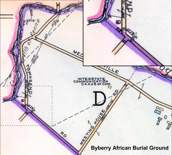
The only historical map that I’ve been able to locate that shows the Byberry African Burial Ground is the “Atlas of Greater Northeast Philadelphia” in Franklin’s Proposed Real Estate Atlases of Philadelphia, Vol. 7 (1953). The small lot is not identified as a burial ground, but the property boundaries are visible:

African American Burial Grounds at Middletown Friends Meeting

More detailed maps, photographs, and other documentation are provided in Byberry Librarian Helen File’s paper on the burial ground and an archaeological study of the site performed by the US General Services Administration in 1993.

The second Quaker meeting in the area to establish an African-American burial ground was Buckingham Friends Meeting, which laid out a small section of their existing graveyard for that purpose in 1807. They report in their minutes:

We have laid out a small portion of Ground within the large Grave Yard at Buckingham to Bury Black People in, Beginning at a stone standing at the North Corner of the Old enclosure, thence N 50 [degrees] E two Perches to a Stone, thence N 40 [degrees] W to a Stone standing at the back Wall of the Yard And to be comprehended by these two lines, the Back Wall, and the Foundation of the Old Wall. The Meeting Uniting therewith, directs Burying in rows beginning at the North End…

Unfortunately the exact location of this plot is unclear, but it is probably located in the northwest section of the current burial ground. Further examination of the meeting’s property records may yield a more exact location. While the author of the Buckingham Meeting’s National Register of Historic Places nomination claims that “The African American burials here were made unnecessary within a few years” after Mount Gilead African Methodist Episcopal Church was constructed nearby in 1837, a recent archaeological survey of the site conducted by Meagan Ratini suggests that the burials may not have taken place there until the 1860s. If that is the case, the African-American burial ground at Buckingham Meeting may have been in use for half a century.

by

A Bird’s Eye View of Doylestown 1886

No comments yet

Categories: Doylestown, Industry and Technology, Maps

Doylestown 1886

Check out this interactive map I put together of Doylestown from 1886. You zoom in to find familiar buildings or see places that have long since been destroyed.  Some details I enjoyed were the old fair grounds on the top right, where CB West is now, the fact that the jail (now the Michener Museum) was pretty much in the middle of nowhere, and the road leading out of town called “Lumberville Road”, which I’m guessing is now Cold Spring Creamery. I also wonder what sort of booze they were cooking up at the fruit distillery.

by

Oliver Paxson on the Ethics of Settling Indian Land

No comments yet

Categories: Land Use, Maps, Native American History, New Hope, Quakerism, Solebury

Oliver Paxson's house is marked as #29 in this map from WWH Davis' History of Bucks County

Oliver Paxson’s house is marked as #29 in this map from WWH Davis’ History of Bucks County

Oliver Paxson was a prominent member of the Religious Society of Friends, and was one of the first residents of New Hope. His home, known as Maple Grove, still stands in New Hope immediately to the east of the New Hope-Solebury school complex. He also operated a stable and a salt store, now Hearth restaurant around the corner from Farley’s Bookshop.

In this letter, published in the first volume of Friends Miscellany (1831), Paxson considers the issue of settling land that has been expropriated from the Indians by force. Paxson presents a surprisingly nuanced and empathetic perspective on the conflict between Indians an European settlers. He believes that Indians own the land they lived on, and that Europeans who want to rightfully occupy that land must purchase it from the Indians on mutually agreeable terms. This stands in sharp contrast to the view of many of his contemporaries, who believed that Indians didn’t actually own the lived on because they didn’t use it properly (“wasting” it as hunting grounds, etc.) and that Europeans farmers were therefore justified in appropriating it. Paxson also believes that capturing land in war or compelling Indians to sell their land through force of arms does not bestow a legitimate right of ownership. When the government has taken Indian land by force Quakers still have an ethical obligation fairly compensate the rightful owners. Otherwise, they’re complicit in the theft of native property.

To support his argument, Paxson cites instances in which Europeans appropriated native land by force resulted in violent reprisals and outright war, and compares that violent outcome to the peaceable outcome that occurred when Quakers made agreements with the Indians to purchase their land on fair terms. William Penn knew that his royal grant did not absolve him of purchasing the land from its true owners, and when a group of Quakers settled in Virginia on land that hadn’t been fairly purchased, the Philadelphia Yearly Meeting raised money to compensate the Indians, “which had a good effect among the tribes.”

He then cites the biblical precedent in the story of Naboth. In that story, the Jews had a different theory of land ownership than the Baalist king. Naboth owned his farm by right of inheritance, and was required by Jewish law to pass it on to his own heirs in turn. Ahab demanded to purchase it as one would purchase an alienable commodity. Because Naboth couldn’t sell his land, Ahab murdered him and stole it, and the prophet Elijah brought God’s wrath upon his family. Quakers, Paxson implied, should not go the way of Ahab.

The letter probably dates to 1802.

TO JOHN SIMPSON OHIO.

New Hope, 5th of 4th mo.

DEAR FRIEND,

I have had a share of thy kind remembrance, with many other friends in the place of thy nativity, which I have no doubt has been gladly received by all the friends thou hast written to; and I thought I felt under some obligation to answer thee. But alas! what shall I say? When I think of writing a letter of social friendship, there is a subject that more or less, for fifty years, hath exercised my mind, and greatly so, of latter times:–that is, the situation of the Indians, unto whom this great and populous country once belonged.

Thou hast often heard and read of the wars in New England and Virginia, in conquests over them, and taking their lands. Not so, when William Penn came to Pennsylvania:–a man who had learned his Master’s lesson, “to do unto all men as he would they should do unto him.” This made his name honourable among the Indians, and it remains so to the present time. But after some time one of his successors, not keeping strictly to this rule, overreached them in a purchase in an extraordinary (or shall I say extravagant) day’s walk, and they revenged it many years afterward, when an opportunity offered, by killing and taking into captivity, many of the white inhabitants. Thou and I can remember these things. How our very ears were made to tingle!

Well, time passed on, till the revolutionary war began. The poor Indians hardly knew what part to take, fearing they should lose all their country in the quarrel between nations of white people; especially if it should turn in favour of the United States (as it finally did) and some of the Seneca Chiefs addressed General Washington near the close of the war, made their submission, and remain peaceably on their reservations in the State of New York.

What comes next to be considered is the state of the country thou livest in. About this time, the white people near the Ohio river went over and made settlements on their lands. They complained of their land and game being taken from them, and found no redress. At length they took up the hatchet, and skirmishing on both sides of the river ensued. The President by this time, thought it his duty to endeavour to put a stop to it, and appointed commissioners to treat of peace, and purchase their land. They met, divers Friends attending, viz. John Parrish, Joseph Moore, Jacob Lindley, and some others. The Indians appeared in a hostile, angry mood, and told the commissioners, they would sell them no land;–but required them to remove the white people that were already settled over the river. The treaty broke up, without doing any thing, and hostilities continued: in consequence of which, the President ordered an armed force to defend the frontiers, and bring the Indians to terms. Sinclair their general. About this time the Meeting for Sufferings was sitting, and a heavy exercise came over the meeting on this account, and a committee was appointed to wait on the President, to intreat him to stay the sword:–which they did in a solemn manner, but all in vain. The expedition was pursued. Sinclair defeated, and many fell in battle. But it did not stop here. A greater force was raised, and a general appointed, more skilful in fighting the Indians, and effectually subdued them; and many of the rightful owners of the country, fell down slain in battle, in defending their just rights:–terms of peace were offered, which they declare, they were forced to accept, it being a price very inadequate to its value.

I do not mean by this, to arraign the government. The United States is a warlike nation;–and conquests made by the sword, are commonly applied to the account of the conquerors. So that in this view of things, it may be considered as an act of generosity in the government to pay the Indians twenty thousand dollars, for a country worth an hundred times that sum. But this wont do for thee nor me, who profess to be redeemed from the spirit of war, so as not even to buy a coat, if we know it to be a prize article. Thou may remember the concern brought on our Yearly Meeting by a few families of Friends in Virginia, who were settled on land not fairly bought of the Indians, and a sum of money was finally raised by Friends in Philadelphia, as a compensation, which had a good effect among the tribes.

I must close this singular epistle, by just observing, that when thou wast concerned some years ago, to publish the glad tidings of the Gospel of peace and salvation to the inhabitants of Ohio, my heart went with thee. And had that been thy sole concern when thou went last, I could again have said Amen. But when I took a view of thy wife and children, going with thee to settle in the country, to buy and sell, and get gain, I was not able to go thy pace. My heart is, nevertheless, filled with tender affection and sympathy for thee, thy dear wife, and her children; and I am persuaded, thou hast not seen the thing in the light I view it, or thou would hardly have taken so much pains to induce Friends to settle, in such numbers, in a land obtained in the manner I have mentioned. Naboth must die, because he refused to sell his inheritance to Ahab; though Ahab offered to give him the worth of it in money, or give him a better for it; yet he would not sell it.1 Mark the sequel. If the Province of Pennsylvania must be visited with the horrors of an Indian War,–many of its inhabitants slain, and many carried into captivity–for one man’s offence, in overreaching the Indians in the purchase of land from them;–what may we then expect in the instance before us? The Indians did refuse to sell their inheritance, till many of them were slain, and they were compelled to it. And would it be a strange thing, if an opportunity should offer for the Indians to revenge their wrongs–if the earth, that hath opened its mouth to receive the blood of the rightful owners of the soil, should again open its mouth to receive the blood of white inhabitants? Which judgment may be averted by acts of righteousness, is the sincere desire of my soul. From thy friend,

OLIVER PAXSON.

1In the Old Testament, Naboth owned a small vineyard next to the palace of King Ahab, who wanted to buy the land. Naboth was forbidden from selling the land by Jewish law. After his offer was rebuffed, Ahab had Naboth killed in order to seize his land. As a result, the prophet Elijah prophesies Ahab’s destruction as punishment for murdering Naboth and stealing his land. (http://en.wikipedia.org/wiki/Naboth)

by

Solebury Friends Meeting Burial Map

No comments yet

Categories: Death, Graves, Maps, Quakerism, Solebury

SoleburyFriendsMeeting-Burial Map-1907(small)

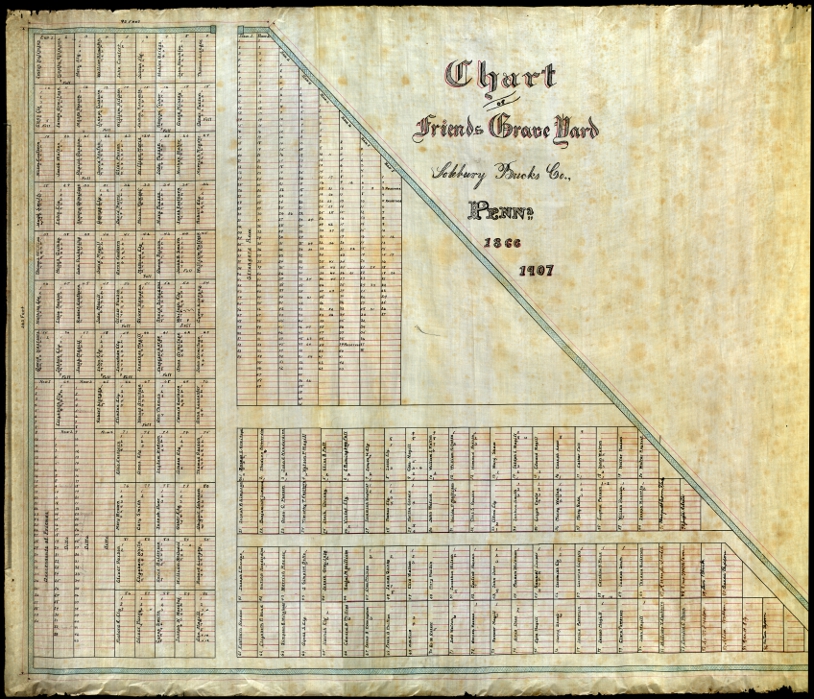
This map of the Solebury Friends Meeting graveyard was drafted in 1907, based on an earlier map from 1866. Unfortunately the 1866 map has suffered some damage and it’s difficult to make out most of the handwriting. The handwriting matches that in the burial book in the Swarthmore archive, which also dates to 1866. That book makes reference to a previous burial chart used as a reference for the 1866 map. It cites “extracts from the old chart” about decisions the meeting made about laying out the graveyard. There are also sections in the list of graves in which the writer of the 1866 book omits names, stating that they were illegible on the old chart.

Illegible on Old Chart

In all likelihood this original map no longer exists, and the names omitted on the 1866 map are probably lost forever.

The 1866 and 1907 maps were almost lost as well. My great-grandfather used them as a reference when creating the modern burial map in the 1960s. Apparently he never returned the maps to the meeting, and I found them in a box of maps that had been stored in my family’s barn.

I deposited them in the archive of the Friends Historical Library at Swarthmore College along with the rest of the meeting’s original records. While there, I used their excellent overhead scanner to digitize the maps. Click on the map above to see the full image.

by

A Trove of Documents Saved from Destruction

No comments yet

Categories: Abolitionists, Buckingham, Graves, Langhorne, Maps, Middletown, Plumstead, Quakerism, Solebury

Petition to Congress

A few months ago my grandfather decided to a do a little spring cleaning. There was a storage unit in our barn that hadn’t been touched in years, full of mildewy furniture and worthless miscellany. He came across a metal container full of maps, mostly showing local topography and zoning. My aunt suggested that I might want them, so they escaped the trash heap.

When I got down to the barn I found a pile of mostly junk, covered in a plastic tarp because we were expecting rain. I found a few items worth keeping: the sled my great-grandmother had when she was a little girl growing up in Battle Creek, Michigan, a wooden tricycle that belonged to my grandfather, and a few plastic trucks for my son to play with. I found the box of maps and popped open the latch, and immediately knew that the contents were far more important than my grandfather had realized.

There were dozens of maps, but among the rolls of paper I recognized a draft of the map my great-grandfather made for the Solebury Friends Meeting burial ground in the 1960s. Then I noticed another roll that was clearly a much older material. With the box sitting in the gravel driveway, I rolled the map out a few inches and discovered that it was in fact two maps rolled together.

SoleburyFriendsMeeting-Burial Map-1907(small)

The first was from 1907.

The second was from 1866.

They were the original maps that by great-grandfather used as a reference for the modern map, and they’d been sitting in our barn for decades, totally forgotten.

I called the person currently in charge of the graveyard to tell him about my find and offered to bring it to the Friends Historical Library at Swarthmore College to deposit it with the rest of the Meeting’s original records, and I held on to them for a few months until I had time to make the trip.

A couple weeks ago I finally I finally had a day off, and decided to bring the maps to Swarthmore. My timing was fortuitous. That Monday I led a graveyard tour at Plumstead Friends Meeting. We assembled in the meetinghouse, and as I led the group outside towards the burial ground, a woman approached me with a box of documents about the meeting. At the time I was too focused on the tour to discuss it, and suggested that she talk to the clerk of the meeting. The next day, however, I was consumed by curiosity. I already had plans to go down the the Friends Historical Library that week, and thought I might be able to bring those papers as well. Luckily I ran into her in Doylestown a couple days later and proposed that I take them for her. She agreed.

When she dropped the documents off the next day, she brought a lot more than the Plumstead material. She also brought a collection of documents from Buckingham Meeting, and there was so much that it took her two trips to unload it from her car.

The Plumstead material turned out to be the notes and research prepared for a pamphlet published for the meeting’s 225th anniversary celebration on 1953, as well as notes about the ceremony itself. There were also two large photographs that were used in the pamphlet, one from c.1875, and one from 1953.

The Buckingham material was rather varied. One box contained about a dozen copies of the book published for Buckingham Meeting’s 225th anniversary in 1923, as well as a block print of the meetinghouse that was used for that book. There was a folder with newspaper clippings and other 20th Century material. Finally, there was a cardboard box that had been saved from Buckingham Meeting by the woman’s father. At some point a few decades ago, the members of Buckingham meeting had decided to indiscriminately “clean” their attic, and this box was a subject of the purge. Like the burial map from Solebury, these documents were almost destroyed.

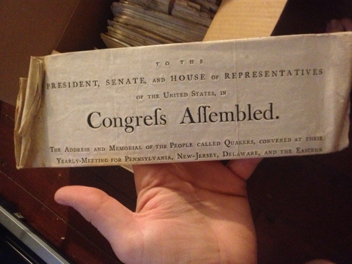
When I opened this final box I got goosebumps. I could tell by looking at the parchment that they were old. Really old. Most of them were tied together with string into little bundles, with a few groupings of loose papers between them. I saw the date “1776” peeking out from one of the bundles. When I brought them home and examined them further I found that some documents dated back to the beginning of the 1700s, and in addition to material from Buckingham, a lot of the documents actually came from Middletown Monthly Meeting. Most of them were excerpts from annual conference of Philadelphia Yearly Meeting, and epistles from the yearly meetings in London and Philadelphia. Some were testimony against members of meeting, or letters from people willingly leaving the Society of Friends. There were a few more recent documents that dealt with the Civil War. Perhaps the most interesting document is a letter written from a Quaker aid mission during the British occupation of Boston. She had kept them in storage for years, hoping to eventually deposit them in the archive, and I was finally able to bring them for her.

Swarthmore Donation - Stack of Papers

For the sake of brevity, I will show the individual documents in separate posts:

by

The Twice-Buried Murderer Joseph Blundin

No comments yet

Categories: Bristol, Crime, Death, Doylestown, Graves, Maps, Tags:

A man sharpens a cradle scythe, similar to Joseph Blundin’s murder weapon.

Today a house sits on the southern corner of Court & East Streets, as nice and unremarkable as any other house in Doylestown. Few would guess that 177 years ago a murderer was buried here. Even fewer would guess that 157 years ago they dug him back up.

This is the story of the executed murderer Joseph Blundin and Doylestown’s forgotten burial ground.

A Crime of Passion

Joseph Blundin was a farmhand with a young family at the time of the crime. He appears on the 1830 US Census living in Bristol with his wife, both in their 20’s, and three children, all under 5 years old. The account of the crime and the public support for Blundin in its aftermath paint him as normal man driven by his circumstances to commit a horrendous act.
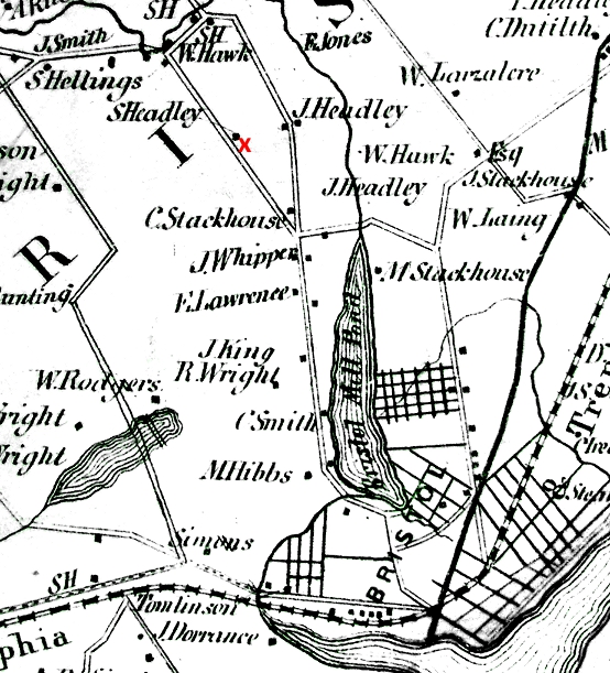
The murderer and victim were harvesting oats on the farm of Samuel Headly, probably the S. Headly marked with a red “X” on this map from 1857. The murder occurred somewhere on the road from Headly’s farm to Bristol.

On the day of the crime Joseph Blundin and his victim, Aaron Cuttlehow, were working together harvesting oats on the farm of Samuel Headly near Bristol. J.H. Battle recounts the details of the crime as revealed during the trial:

The prisoner and deceased were at work on Sunday, July 27th [1834], with other men, five or six, engaged in cradling oats. At dinner one of the hands ran out of doors with a pie, deceased and the prisoner chasing him. In their playfulness a shoe was thrown which hit the prisoner. Shortly afterward the deceased came into the house crying, and said the prisoner had hit him on the head with a stone. This disturbance was settled, and they all went to the field to cradle oats. When nearly done a quarrel arose between the prisoner and the deceased, and the prisoner was thrown down and received several blows from [the] deceased in the face. The deceased with another then helped him upon his feet, and his knees giving way under him, they assisted him up a second time. The prisoner then took his cradle and started for home. He was asked to ride twice, but refused, and said, angrily, he would walk. From fifteen minutes to half an hour later he was overtaken by the wagon, walking slowly. He was asked to get up and ride. The prisoner made no reply, but raised his cradle from his shoulder and struck at the deceased hitting the cradle of the deceased, which he raised to guard the blow; the deceased at the same time losing his cradle from his hand, which fell upon the ground. The deceased (Cuttlehow) then sprang from the wagon to make his escape, but stumbled and fell as he reached the ground. When he had crawled a few paces the prisoner came upon him with his cradle uplifted and struck the scythe through the neck of Cuttlehow. The latter cried, “Take it out, take it out!” sank on the ground and died in one or two minutes. Some one said to the prisoner: “He will die,” who replied: “Let him die.” Liquor had been used in the field, but there was no satisfactory evidence that the prisoner was intoxicated. The jury was out eleven or twelve hours, and returned a verdict of murder in the first degree.

We don’t know who started the fight, but it’s clear that the dead man had seriously beaten Blundin in the earlier scuffle, and that Blundin was emotionally distressed by the fight. Instead of escalating the conflict he attempted to walk home alone, only to be confronted again. After being pushed one last time by the other farmhands, he lashed out and killed Cuttlehow with the tool he happened to be carrying. All of this evidence portrays the crime as a temporary lapse by an otherwise decent man rather than the premeditated work of a cold-blooded killer.

After he was sentenced to die by hanging, the public rose up in support of him. While the facts of the crime were not disputed, the death sentence issued seemed harsh and unnecessary. Battle reports that even Charles E. DuBois, the Deputy Attorney-General for the Commonwealth, “was overcome with emotion in reading the indictment to the unfortunate man.” The citizens of Bucks County appealed to the government for mercy, petitioning the Governor Goerge Wolfe and both houses of the State Assembly in an attempt to have his sentence commuted to life in prison. They attempted to save Blundin through multiple avenues, begging for the Governor and legislature to take action in his case specifically as well as attempting to change the state laws regarding criminal sentencing by giving the governor the power to commute death sentences to life in prison or by abolishing the death penalty altogether.

The general thrust of their appeals can be seen in the debate that took place on the floor of the Pennsylvania House of Representatives, where a representative named Harrison introduced an amendment:

…in accordance with the wishes of a large number of constituents; men of the highest respectability who believed, and honestly believed what is set forth in petition to the legislature, that at the time Joseph Bliindin committed the act for which he has been sentenced to death, he was not in a sound state of mind. The unfortunate individual was born and brought up in his vicinity; he has a family consisting of a wife and several children, and a general feeling pervades that community, that he should become the object of legislative mercy. In addition to these wishes in of Joseph Blundin, a general feeling was manifested in favour of the abolishment of capital punishment in all cases…

Unfortunately, Blundin’s supporters failed in their attempts. Those opposed to the measures claimed that any action in his case was unconstitutional, either by violating the separation of powers or because such a law would affect one man instead of all people under their jurisdiction. Finally, after multiple stays of execution, Blundin was scheduled to die on Friday, August 14th, 1835 between noon and 3pm.

Blundin made one final attempt to save his own life by escaping from the Doylestown jail. Battle describes the failed escape as follows:

On a Sunday in May Blundin attempted to make his escape from the jail. He managed to cut off the rivets of his hopples, burn a hole through the floor, and, after gaining the jail yard attempted by means of a rope formed of his bedding, to scale the outer wall. The fastenings gave way when the prisoner was near the top and he fell to the ground, where he lay in a bruised and helpless condition until found in the morning by the sheriff. Such was the sympathy of the public that a rumor that the sheriff left the means of escape within reach of the prisoner and then left the building to give him an opportunity to use them, obtained general credence and no marked disapproval. The unfortunate man was carried back to his cell and on the day appointed by the governor’s last respite was executed in the yard of the jail. The prisoner was unable to stand on account of his injuries, but he met his fate with resignation and courage.

Then, by way of the gallows, Joseph Blundin found his temporary resting place in the now forgotten potter’s field.

The Doylestown Potter’s Field

In the first half of the 19th century this plot of land was the county potter’s field, a burial place of last resort for the indigent and a site to inter the unclaimed bodies of strangers and prisoners. Very little is recorded of the Doylestown potter’s field. Like the almshouse, the courthouse, and the county jail, the potter’s field probably came into being around the time that the county seat moved from Newtown to Doylestown in 1812. I could only find the potter’s field on one map, W.E. Morris’ 1850 atlas of Bucks County:

The only mention of those buried here comes from W.W.H. Davis’ History of Bucks County, Volume II:

The old “potter’s field,” where several persons were buried, including one Blundin, of Bensalem [actually Bristol], hanged for murder about 1838, at the corner of Court and East streets was sold several years ago by authority of an act of Assembly and now belongs to a private owner.

I was able to act of Assembly that Davis mentions. Passed on May 7th, 1855, the act instructs Bucks County to remove the bodies and sell the land, stating:

…it shall be the duty of the commissioners of the county of Bucks… to remove or cause to be removed to the burial ground of the Bucks county almshouse, the remains of all persons now interred in the public burial ground, situate at the corner of Court street and East street, in the borough of Doylestown, and known as Potter’s Field, and that the same shall no longer be used as a place of burial.

The almshouse opened in the spring of 1810, and the first inmate to die there was a black woman named Dinah, allegedly 115 years old. According to almshouse records (List of Paupers in the Almshouse 1810-1833, p.31, available on microfilm at the Spruance Library), Dinah died on April 20th, 1810, and the almshouse supplied her with a “cape shirt hankercheif and coffin” for her burial. While I haven’t been able to find any information about the almshouse burial ground, it preceded the Doylestown potter’s field by at least a couple years and was probably used concurrently.

At some point, the almshouse stopped using their own burial ground and began interring inmates at Doylestown Cemetery. I talked to Kat Landis, whose family oversees cemetery, and she said that the back row of the cemetery was laid out as a “Strangers Row” with inexpensive plots. According to her, this area became the burial ground for inmates from the almshouse, prisoners from the county jail, and people who died at the Doylestown hospital. This “back row” is now in the center of the cemetery near the main gate, since Hope Cemetery was added next to Doylestown Cemetery and the two were later unified. My guess is that when these cheap plots became available there was no more need for a government maintained burial ground. I have found some written evidence of this in the Almshouse and Hospital Register 1872-1889, which reports that inmate Henry Puff was buried at Doylestown Cemetary on the November 29th, 1883.

Doylestown Cemetery was founded in 1849, and probably wasn’t in operation yet when the 1850 map was made. By 1857, however, the cemetery is presented in the atlas published by Khun & Shrope. You can see that the Dolyestown Cemetery has been added to the map, but the potter’s field is gone:

Whether Joseph Blundin and the others buried in the potter’s field were actually disinterred may be up for debate. The graves in potter’s fields are usually unmarked, and the success of disinterment would depend on how systematically the graves were laid out and how well the locations were recorded. I’m sure they made their best effort to clear the land of bodies before selling it to a private owner, but after 20 years in the ground did the county remember the location of Blundin’s grave? He probably lies on the almshouse grounds, but every time I pass the old potter’s field I wonder if any graves remain.


(The house now standing on the potter’s field.)
by

Springdale, Huffnagle, Rosenthal… Darkey Town?

No comments yet

Categories: Black History, Demography, Maps, New Hope, Racism, Solebury

Segregated housing or unfortunate surname?

Today while poring over J.D. Scott’s Combination Atlas Map of Bucks County (1876), I discovered this detail in the map of New Hope Borough. The row of houses on Stoney Hill Road above Joshua Whiteley’s cotton mill (now the Inn at the Ruins) is labelled Darkey Town.

At different times the larger hamlet was known as Springdale, Huffnagle, and Rosenthal, but none of the sources I’ve checked make any mention of Darkey Town. MacReynolds’ Place Names in Bucks County provides some details about the development of the hamlet. Robert Heath built Solebury’s first grist mill here in 1707, and the William Maris moved here in 1812 and built the cotton mill (owned by Whiteley on this map) and the mansion known as Springdale.  When the railroad line was put in, Springdale became first stop southwest of New Hope. Maris sold the property to the Huffnagle family (Dr. John Huffnagle appears on this map). The hamlet was then called Huffnagle until it was renamed for artist Albert Rosenthal who purchased the ruined mansion in 1928 and set up a studio. The houses on Mechanics St. and Stoney Hill probably belonged to the skilled and unskilled laborers that worked at the mills.

I hate to jump to conclusions, but of course I’m wondering if the name Darkey Town is being used in the pejorative sense to label a section of New Hope Borough where black families resided. There are two bits of evidence that reinforce this idea. First off, one of the residents is listed only as “Old Bob.” Every other resident I’ve found in this atlas is listed by surname or at very least by first and last initial (compare this to J. Huffnagle, M.D. a few houses to the west). Why was Old Bob not afforded the same respect and formality given to every other resident and landowner? More importantly, the building labelled “M.E. Ch.” may be a Methodist Episcopalian Church. This might be related to the Mount Gilead African Methodist Episcopalian Church, founded by former slaves on Buckingham Mountain in 1835.

Of course, this hypothesis is discordant with the standard narrative of race relations in Bucks County. You always read that the area was remarkably tolerant thanks to the salutary influence of the Quakers. It’s conceivable that some less educated mill workers in this industrial valley had a different stance on race relations than the Quaker farmers.

My biggest question is why this name doesn’t appear elsewhere. George MacReynolds was the librarian of the Bucks County Historical Society, so he must have seen this atlas. Did he omit this place name on purpose? This map was published in 1876, when minstrel shows were a popular source of entertainment and played a significant role in exporting the stereotypes of Southern racism to the rest of the country. A quick Google search reveals that the term “Darkey Town” was used in the South to describe black neighborhoods, such as this one on the outskirts of Lebanon, Virginia. By the time MacReynolds published Place Names in 1942 the name would have been downright offensive. Likewise, MacReynolds may have purposefully omitted it because the Darkey Town label was a spurious editorial flourish by the mapmaker rather than a name that locals actually used to describe that area.

The next time I’m at the Spruance Library I’ll see what else I can find.

For a modern view:

If you enter Google Street View there are a few images of the ruins.